Journal Papers

May, 2026
International Journal of Remote Sensing,
Mitigating cloud effects in Sentinel-2 time-series image classification using PCA-enhanced imputations
Tee-Ann Teo, Yu-Liang Lin
https://doi.org/10.1080/01431161.2026.2667023
This study investigated cloud-filling methods and U-Net-based architectures for time-series Sentinel-2 satellite images in land use and land cover (LULC) classification.

April, 2026
Engineering Geology, 368, 108774.
Assessing earthquake-induced displacements of large-scale landslide by
in-situ monitoring and discrete element analysis
Meng-Chia Weng, Wei-An Chao, Che-Ming Yang, Tee-Ann Teo, Kuo-Wei Li, Yu-Ting Hsiao
https://doi.org/10.1016/j.enggeo.2026.108775
This study integrates multi-source monitoring and DEM modeling to analyze Taiwan landslide behavior, revealing earthquake-triggered accelerations, a failure threshold (841.5 gal), and frequency-dependent responses, advancing hazard assessment and risk mitigation.

April, 2026
Journal of Building Engineering, 125, 116118.
Hybrid bend-loss optical fiber sensing and photogrammetry for deformation and damage monitoring of masonry structures
Terry Y.P. Yuen, Tzu-Han Wen, Tee-Ann Teo, Yu Hao, Ko-Hsin Mei, Wen-Kiat Chia
https://doi.org/10.1016/j.jobe.2026.116118
This study proposes a smart and automated structural deformation monitoring framework integrating bend-loss polymer optical fiber sensing (OFS) with advanced photogrammetry techniques for continuous three-dimensional deformation and damage assessment of masonry structures subjected to out-of-plane loading, which is a primary cause of collapse during earthquakes.

February, 2026
Drones, Vol.10, Issue 3, 185.
Semantic-Guided Matching of Heterogeneous UAV Imagery and Mobile LiDAR Data Using Deep Learning and Graph Neural Networks
Tee-Ann Teo, Yu Hao, Pei-Cheng Chen
https://doi.org/10.3390/drones10030185
This study proposes a novel air-to-ground semantic feature matching framework to achieve precise geometric registration between UAV imagery and Mobile Lidar data by effectively incorporating semantic-constraint deep learning-based matching.

December, 2025
Scientific Report, Vol.15, 44609.
A High-Resolution Machine Learning and Multi-source Remote Sensing Approach for Estimating Net Primary Productivity in Campus Green Spaces
Sung, C. H., C. Wijaya, A. K. Asri, Y. R. Chern, T. A. Teo, W. Y. Liu, C. H. Lee, Y. L. Hsu, C. D. Wu
https://doi.org/10.1038/s41598-025-28350-6
This research proposes an innovative framework that integrates Machine Learning classification, the
Carnegie-Ames-Stanford Approach (CASA), unmanned aerial vehicles (UAV), and multi-source data to
estimate the net primary productivity (NPP) of campus green spaces.

October, 2025
Buildings, Vol.15, Issue 19, 3584.
A Markerless Photogrammetric Framework with Spatio-Temporal Refinement for Structural Deformation and Strain Monitoring
Tee-Ann Teo, Ko-Hsin Mei, Terry Y.P. Yuen
https://doi.org/10.3390/buildings15193584
This study proposes a spatio-temporal photogrammetric refinement framework that enhances the accuracy of three-dimensional (3D) deformation and strain analysis by integrating advanced filtering techniques into markerless image-based measurement workflows.

August, 2025
Environmental Pollution, Vol. 383, 126879.
Assessing 3-D variability of ultrafine particle using a Geo-AI modelling approach: A case study in Zhunan-Miaoli, Taiwan
Chia-Wei Hsu, Yinq-Rong Chern,Jun-Jun Su, Pei-Yi Wong, Aji Kusumaning Asri, Candera Wijaya, Yu-Cheng Chen, Shih-Chun Candice Lung,Ta-Chih Hsiao, Tee-Ann Teo,Yi-Liang Shih, Chih-Da Wu
https://doi.org/10.1016/j.envpol.2025.126879
This study examined the 3-D distribution of PM0.1 in the Zhunan and Toufen regions in Miaoli, Taiwan

March, 2025
GIScience & Remote Sensing, Vol. 62, Issue 1.
Enhancing urban resilience through Tomo-PSInSAR-based structural health monitoring
Yi-Ching Chen, Yunung Nina Lin, Tee-Ann Teo, Chin-Yeh Chen, Tian-Yuan Shih, Hsin Tung
DOI:10.1080/15481603.2025.2482329
This study explores the feasibility of large-scale SHM using tomographic persistent-scatterer interferometric synthetic aperture radar (Tomo-PSInSAR) within an urban planning context.

March, 2025
Geomatics, Natural Hazards and Risk, Vol. 16, Issue 1.
An object-based spectral and elevation feature fusion framework for landslide mapping using time-series Landsat-8 imagery
Tsung-Han Wen, Tee-Ann Teo
DOI:10.1080/19475705.2025.2471014
This study presents an object-based spectral and elevation feature fusion framework for landslide mapping using time-series Landsat-8 imagery, significantly improving detection accuracy and robustness.

February, 2025
Buildings, Vol. 15, Issue 5.
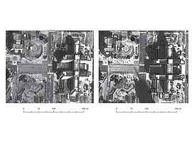
Building Change Detection in Aerial Imagery Using End-to-End Deep Learning Semantic Segmentation Techniques
Tee-Ann Teo, Pei-Cheng Chen
DOI: 10.3390/buildings15050695
This research conducts building change detection through a data fusion approach, integrating RGB, DSM, and building maps.

September, 2024
Buildings, Vol. 14, Issue 9.
Spatial Analysis with Detailed Indoor Building Models for Emergency Services
Min-Lung Cheng, Fuan Tsai, Tee-Ann Teo
DOI: 10.3390/buildings14092798
This research integrates three-dimensional (3D) indoor building models and their attributes to simulate an emergency evacuation scenario.

July, 2024
ISPRS International Journal of Geo-Information, Vol. 13.
Automatic Vehicle Trajectory Behavior Classification Based on Unmanned Aerial Vehicle-Derived Trajectories Using Machine Learning Techniques
Tee-Ann Teo, Min-Jhen Chang, Tsung-Han Wen
This study introduces an innovative scheme for classifying vehicle behaviors from unnamed aerial vehicle(UAV)-derived trajectory.

April, 2023
Developments in the Built Environment, Vol. 14.
Evaluating the accuracy and quality of an iPad Pro's built-in lidar for 3D indoor mapping
Tee-Ann Teo, Chen-Chia Yang
DOI: 10.1016/j.dibe.2023.100169
This study analyzed the scanning accuracy of iPad Pro lidar and evaluated its suitability for scan-to-BIM applications.

February, 2023
International Journal of Applied Earth Observation and Geoinformation, Vol. 116.
Comparison between image- and surface-derived displacement fields for landslide monitoring using an unmanned aerial vehicle
Tee-Ann Teo, Yu-Ju Fu, Kuo-Wei Li, Meng-Chia Weng, Che-Ming Yang
DOI: 10.1016/j.jag.2022.103164
This study determined the benefits of using UAV-image-derived 3D point clouds to extract 3D displacement fields for landslide monitoring.

November, 2022
Journal of the Chinese Institute of Engineers, Vol. 46.
Effectiveness of the red-edge band of RapidEye in land cover classification
Tzu-Ying Chen, Hui-Hsin Chen, Tee-Ann Teo, Peter Tian-Yuan Shih
DOI: 10.1080/02533839.2022.2141339
This study examined the effectiveness of the red-edge band using RapidEye satellite images for land cover classification.

October, 2021
Journal of Cleaner Production, Vol. 317.
Using land-use machine learning models to estimate daily NO2 concentration variations in Taiwan
Pei-Yi Wong, Huey-Jen Su, Hsiao-Yun Lee, Yu-Cheng Chen, Ya-Ping Hsiao, Jen-Wei Huang, Tee-Ann Teo, Chih-Da Wu, John D. Spengler
DOI: 10.1016/j.jclepro.2021.128411
This study demonstrates the value of combining Hybrid Kriging-LUR model and an XGBoost algorithm to estimate the spatial-temporal variability of NO2 exposure.

Environmental Modelling and Software, Vol. 139.
Incorporating Land-Use Regression into Machine Learning Algorithms in Estimating the Spatial-Temporal Variation of Carbon Monoxide in Taiwan
DOI: 10.1016/j.envsoft.2021.104996
This paper is the first of its kind to use machine learning algorithms in conjunction with a Land-use Regression model for predicting the spatiotemporal variation of CO concentrations in Taiwan.

Remote Sensing, Vol. 13, Issue 4.
Spatiotemporal Fusion of Formosat-2 and Landsat-8 Satellite Images: A Comparison of “Super Resolution-Then-Blend” and “Blend-Then-Super Resolution” Approaches
This study develop a hybrid spatiotemporal image fusion approach involving a deep learning model and a physical model.
Terrestrial, Atmospheric & Oceanic Sciences, Vol. 30, No. 4.
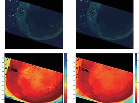
Cloud component removal for shallow water depth retrieval with multi-spectral satellite imagery
Po-Yao Tsou, Peter Tian-Yuan Shih, Tee-Ann Teo
DOI: 10.3319/TAO.2018.09.10.01
This research utilizes artificial neural network and physical model to estimate water depth.

Remote Sensing, Vol. 10, Issue 7.
The Benefit of the Geospatial-Related Waveforms Analysis to Extract Weak Laser Pulses
Tee-Ann Teo and Wan-Yi Yeh
This study proposes a method to analyze the geospatial relationship between the return signals by combining the sequential waves.


Advanced Engineering Informatics, Vol. 30, Issue 3.
BIM-oriented indoor network model for indoor and outdoor combined route planning
DOI: 10.1016/j.aei.2016.04.007
This study proposes an indoor network model from BIM for various indoor–outdoor route planning applications.

Terrestrial, Atmospheric & Oceanic Sciences, Vol. 27, No. 4.
Object-based Land Cover Classification Using Airborne Lidar and Different Spectral Images
Tee-Ann Teo and Chun-Hsuan Huang
DOI: 10.3319/TAO.2016.01.29.01(ISRS)
This study proposes an object-based land cover classification method using a combination of lidar and different spectral images.

Terrestrial, Atmospheric & Oceanic Sciences, Vol. 27, No. 4.
Geomorphological Change Detection Using an Integrated Method: A Case Study on the Taan River Watershed, Taiwan
Jyun-Yi Wu, Tee-Ann Teo, and Peter Tian-Yuan Shih
DOI: 10.3319/TAO.2016.01.29.03(ISRS)
This study provides a scheme for detecting both horizontal and vertical movements for river evolution in an integrated manner.

Remote Sensing, Vol. 7, Issue 12.
Radiometric Block Adjustment for Multi-Strip Airborne Waveform Lidar Data
Tee-Ann Teo and Hsien-Ming Wu
This study proposes a radiometric normalization model to improve the radiometric consistency between multi-strip lidars.

IEEE Journal of Selected Topics in Applied Earth Observations and Remote Sensing, Vol. 8, Issue 10.
Pole-Like Road Object Detection From Mobile Lidar System Using a Coarse-to-Fine Approach
Tee-Ann Teo and Chi-Min Chiu
DOI: 10.1109/JSTARS.2015.2467160
This study presents a coarse-to-fine detection for roadobject extraction that automatically detects pole-like objects from mobile lidar system data.

Remote Sensing, Vol. 7, Issue 5.
Empirical Radiometric Normalization of Road Points from Terrestrial Mobile Lidar System
Tee-Ann Teo and Hui-Lin Yu
This study proposes a range normalization method to reduce the abnormal amplitude phenomenon at near distance.

December, 2014
Remote Sensing, Vol. 6, Issue 12.
Surface-Based Registration of Airborne and Terrestrial Mobile LiDAR Point Cloud
Tee-Ann Teo and Shih-Han Huang
This study proposed a scheme to co-register the 3-D point clouds scanned from airborne and terrestrial vehicle platforms to increase the details of urban scenes.

December, 2013
The Photogrammetric Record, Vol. 28, Issue 144.
Digital elevation quality derived from medium-format digital cameras
Shih, P.T.Y., Wu, J.Y., Teo, T.A. and Tsai, J.C.
This study analysed the quality of digital elevation data derived from a medium-format camera using lidar data.

October, 2013
IEEE Journal of Selected Topics in Applied Earth Observations and Remote Sensing, Vol. 6, Issue 5.
Automatic Co-registration of Optical Satellite Images and Airborne Lidar Data using Relative and Absolute Orientations
Tee-Ann Teo and Shih-Han Huang
DOI: 10.1109/JSTARS.2012.2237543
This study proposes an automatic co-registration procedure for very high resolution satellite stereo images and lidar point clouds.
International Journal of Remote Sensing, Vol. 34, Issue 4.
Line-based Rational Function Model for High Resolution Satellite Imagery
Tee-Ann Teo
DOI: 10.1080/01431161.2012.720044
This study proposes mathematical models of a line-based rational function model.

International Journal of Remote Sensing, Vol. 34, Issue 3.
Lidar-based change detection and change-type determination in urban areas
Tee-Ann Teo and Tian-Yuan Shih
DOI: 10.1080/01431161.2012.714504
This article proposes an object-based change detection scheme to detect changes in buildings using multi-temporal interpolated lidar data.

July, 2012
IEEE Transactions on Geoscience and Remote Sensing, Vol. 50, Issue 7.
Geometric Integration of Heterogeneous Models for Multisatellite Image Positioning
Liang-Chien Chen, Wen-Chi Chang, Tee-Ann Teo
DOI: 10.1109/TGRS.2011.2176739
This paper proposes two approaches to block adjustment for multisensor satellite images.

March, 2012
International Journal of Remote Sensing, Vol. 33, Issue 6.
Multi-type change detection of building models by integrating spatial and spectral information
Liang-Chien Chen, Wen-Chi Chang, Tee-Ann Teo
DOI: 10.1080/01431161.2011.593584
This work proposes a new scheme that detects changes in old building models with new LIDAR point clouds and aerial imagery.


December, 2011
Photogrammetric Engineering and Remote Sensing, Vol. 77, No. 12.
Bias Compensation in a Rigorous Sensor Model and Rational Function Model
Tee-Ann Teo
This study compares the geometric performance of the bias-compensated rigorous sensor model (RSM) and rational function model (RFM).

April, 2010
IEEE Transactions on Geoscience and Remote Sensing, Vol. 48, Issue 4.
DEM-Aided Block Adjustment for Satellite Images with Weak Convergence Geometry
Tee-Ann Teo, Liang-Chien Chen, Chien-Liang Liu, Yi-Chung Tung, and Wan-Yu Wu
DOI: 10.1109/TGRS.2009.2033935
This study proposes and compares different block adjustment methods for the processing of satellite images using the digital elevation model (DEM) as the elevation control.

September, 2008
Photogrammetric Engineering and Remote Sensing, Vol. 74, No. 9.
Shaping Polyhedral Buildings by the Fusion of Vector Maps and Lidar Point Clouds
Liang-Chien Chen, Tee-Ann Teo, Chih-Yi Kuo, Jiann-Yeou Rau
This paper integrates lidar point clouds and large-scale vector maps to perform building modeling.

Photogrammetric Record, Vol. 22, Issue 117.
Occlusion-Compensated True Orthorectification For High-Resolution Satellite Images
Liang Chien Chen, Tee-Ann Teo, Jen Yu Wen, Jiann Yeou Rau
DOI: 10.1111/j.1477-9730.2007.00416.x
This paper describes a method to generate true ortho-images from high-resolution satellite images

Asian Journal of Geoinformatics, Vol. 7, No. 3.
Building Reconstruction Using a Split-Shape-Merge Method
Tee-Ann Teo, Liang-Chien Chen, Jiann-Yeou Rau, Szu-Jen Chen
DOI: 10.1111/j.1477-9730.2007.00416.x
This paper presents a scheme for the reconstruction of building models from lidar data and vector maps by using a split-shape-merge approach.

May, 2006
Photogrammetric Engineering and Remote Sensing, Vol. 72, No. 5.
The geometrical comparisons of RSM and RFM for Formosat-2 satellite images
Liang-Chien Chen, Tee-Ann Teo, Chien-Liang Liu
This paper compares the geometric performance between the rigorous sensor model(RSM) and rational function model(RFM) for FORMOSAT-2 images.

November, 2005
Photogrammetric Engineering and Remote Sensing, Vol. 72, No. 5.
Adaptive patch projection for the generation of orthophotos from satellite images
Liang-Chien Chen, Tee-Ann Teo, Jiann-Yeou Rau
This study proposes a procedure for the fast orthorectification of satellite images.
期刊論文

December, 2021
航測及遙測學刊 Journal of Photogrammetry and Remote Sensing, Vol. 26, No. 4.
應用深度學習於航照正射影像之房屋偵測
Building Detection from Aerial Orthoimage Using Deep Learning Technology
張智安(Tee-Ann Teo), 傅于洳(Yu-Ju Fu)
DOI: 10.6574/JPRS.202112_26(4).0002
此研究以深度學習技術建立智慧辨識方法,使用臺灣通用電子地圖搭配航照正射影像建立訓練資料集,萃取影像中房屋區域並偵測前後期房屋變遷區域。
This research uses deep learning technology to identify building regions and changed areas from multi-temporal aerial orthoimage.

January, 2021
國土測繪與空間資訊 Taiwan Journal of Geoinformatics, Vol. 9, No. 1.
東沙共站封閉型壓力式潮位計觀測值比對
On the Comparison of Three Self-contained Pressure Tide Gauges in Dongsha
史天元(Tian-Yuan Shih), 薛憲文(Shiahn-Wern Shyue), 張智安(Tee-Ann Teo)
此研究分析三具安置於東沙潮位站之壓力式潮位計,以了解資料特性。
This study analyzes the data collected by three gauges deployed at the Dongsha tide station.

January, 2021
國土測繪與空間資訊 Taiwan Journal of Geoinformatics, Vol. 9, No. 1.
犯罪熱點分析方法及其應用:以2015-2018年桃園市機車竊盜犯罪為例
Crime Hotspot Analysis: A Case Study of Vehicle Theft in Taoyuan City, 2015-2018
溫重翰(Tsung-Han Wen), 張智安(Tee-Ann Teo), 史天元(Tian-Yuan Shih)
本研究探討桃園市機車竊盜的犯罪地圖製作,分別以宏觀層次與微觀層次兩個部分分析。
This study investigates the theft of motorbikes in Taoyuan metropolitan area through mapping the locations of reported theft.

December, 2018
航測及遙測學刊 Journal of Photogrammetry and Remote Sensing, Vol. 23, No. 4.
以球形及圓柱投影之環景影像產製三維點雲
The Generation of 3D Point Clouds from Spherical and Cylindrical Panorama Images
張智安(Tee-Ann Teo), 張正岳(Cheng-Yueh Chang)
DOI: 10.6574/JPRS.201812_23(4).0004
此研究探討不同投影方式之多相機影像於三維點雲重建。
This study compares the 3-D point clouds generated from frame images and panorama images using different projection modes.

July, 2018
國土測繪與空間資訊 Taiwan Journal of Geoinformatics, Vol. 6, No. 2.
空間大數據基礎架構平台之簡介
Introduction to Geospatial Big Data Infrastructure
張智安(Tee-Ann Teo), 楊筑鈞(Chu-chun Yang), 傅于洳(Yu-Ju Fu)
本文介紹現有GBDI平台空間資料數據集、平台功能及應用範例,並以Google Earth Engine平台建立台灣地區無雲影像為應用案例,說明GBDI的概念及可能應用。
This study introduces the existing GBDI platforms in the way of data sets, functions and applications. Moreover, Taiwan cloud free image generation by GEE was also provided as a case study.

June, 2018
航測及遙測學刊 Journal of Photogrammetry and Remote Sensing, Vol. 23, No. 2.
以線散函數衍生特徵評估影像模糊度-應用於UAV影像篩選
LSF-derived Feature for Image Quality Assessment - A Case Study on UAV Image Selection
張智安(Tee-Ann Teo), 溫張雲晟(Yun-Cheng Wen-Chang)
DOI: 10.6574/JPRS.201806_23(2).0004
此研究提出以線散函數衍生特徵,考慮模糊強度與方向性,自動化估計影像品質。
This study presented an automatic LSF (line spread function)-derived feature to detect blurred image.

March, 2018
航測及遙測學刊 Journal of Photogrammetry and Remote Sensing, Vol. 23, No. 1.
以Protégé建立OSM房屋相關標籤之網路本體語言
Web Ontology Language for OSM's Building using Protégé
張智安(Tee-Ann Teo), 謝旻哲(Min-Che Hsieh)
DOI: 10.6574/JPRS.201803_23(1).0005
此研究以 Protégé建立開放街圖房屋相關標籤之網路本體語言。
This study develops an ontology-based framework for the building in OpenStreetMap.

航測及遙測學刊 Journal of Photogrammetry and Remote Sensing, Vol. 22, No. 3.
半全域匹配法於福衛二號立體影像之數值地表模型重建
Semi-Global Matching for DSM Generation using Formosat-2 Stereo Images
張智安(Tee-Ann Teo), 郭怡伶(I-Ling Kuo)
DOI: 10.6574/JPRS.2017.22(3).3
此研究提出物空間半全域演算法(Object-based SGM)重建數值地表模型(Digital Surface Model)。
This study proposed an object-based SGM (OSGM) to overcame the problem of non-linear epipolar line for push-broom satellite image.

航測及遙測學刊 Journal of Photogrammetry and Remote Sensing, Vol. 21, No. 3.
開放街圖之三維建物模型品質評估:以交通大學校區為例
Quality Assessment of the 3D Building Models from OpenStreetMap: A Case Study of NCTU Campus
張智安(Tee-Ann Teo), 謝旻哲(Min-Che Hsieh)
DOI: 10.6574/JPRS.2016.21(3).5
此研究建立開放街圖(OpenStreetMap)之三維建物模型驗證程序並驗證其精度。
This study establishes the evaluation procedure and analyzes the data quality for 3D building models of National Chiao Tung University from OpenStreetMap.

航測及遙測學刊 Journal of Photogrammetry and Remote Sensing, Vol. 20, No. 2.
以多尺度萃取方法進行車載光達資料之類桿狀道路物件重建
Pole-like Road Object Extraction from Mobile Lidar System Based on Multi-scale Approach
張智安(Tee-Ann Teo), 邱繼珉(Chi-Min Chiu)
DOI: 10.6574/JPRS.2016.20(2).2
此研究發展車載光達資料自動化道路類桿狀物件重建方法。
This study develops a novel approach for pole-like road objects extraction from mobile lidar system data.

營建管理季刊 Construction Management Journal, No. 103.
BIM技術導入河堤工程設計之可行性研究
Feasibility Study of Applying Building Information Modeling to Support Dike Design
王琨淇(Kun-Chi Wang), 陳霓盈(Ni-Ying Chen), 王維志(Wei-Chih Wang), 張智安(Tee-Ann Teo), 葉克家(Keh-Chia Yeh), 孔承儒(Cheng-Ju Kung)
DOI: 10.6505/CMJ-2016-103-32-14
此計畫主要以頭前溪流域與苦苓腳工程為例,探討BIM導入河堤設計過程之可行性。
This research investigates the feasibility of applying BIM to the design of a dike project that is located on Touqian river basin.

航測及遙測學刊 Journal of Photogrammetry and Remote Sensing, Vol. 19, No. 2.
應用空載全波形光達資料與波形分析與地物分類
Waveform Analysis and Landcover Classification Using Airborne Full-Waveform Lidar Data
林郁珊(Yu-Shan Lin), 張智安(Tee-Ann Teo)
DOI: 10.6574/JPRS.2014.19(2).1
本研究分析與評估原始波形數據和擬合成果兩者間的精度。
This study calculates several accuracy assessment indicators between raw waveform data and fitting function for quality assessment.

航測及遙測學刊 Journal of Photogrammetry and Remote Sensing, Vol. 17, No. 4.
多尺度三維數位房屋模型建置
Three Dimensional Digital Building Modeling for Multiple Level of Detail
蔡富安(Fu-An Tsai), 張智安(Tee-Ann Teo), 張桓(Huan Chang), 陳良健(Liang-Chien Chen), 陳杰宗(Chieh-Tsung Chen)
DOI: 10.6574/JPRS.2013.17(4).3
此研究利用各種空間數據研發出符合OGC CityGML所定義的LOD1、LOD2及LOD3之3D房屋模型建置方法。
This paper presents viable strategies for generating 3D building models of different levels of details from assorted sources of spatial data.

科儀新知學刊 Instruments Today, No. 195.
行動測量系統於道路資訊萃取應用
Applications of Mobile Mapping System in Road Information Extraction
張智安(Tee-Ann Teo), 連以諾(Yi-No Lien), 蔡富安(Fuan Tsai), 陳宗杰(Chieh-Tsung Chen)
此研究透過車載光達獲取的點雲資料萃取道路點雲,並從中獲取道路的幾何資訊。
This paper extracts the road points from the mobile lidar points cloud, and then obtaining the geometrical information of the road.

航測及遙測學刊 Journal of Photogrammetry and Remote Sensing, Vol. 16, No. 3.
測深光達波形與水深、底質關係觀察
Exploration on Waveforms of Bathymetric Lidar
林暐尊(Wei-Tsun Lin), 史天元(Tian-Yuan Shih), 張智安(Tee-Ann Teo)
DOI: 10.6574/JPRS.2012.16(3).6
此研究使用東沙及澎湖之AHAB HawkEye IIb掃描數據及Coastal Survey Studio(CSS)軟體進行數據分析。
This study analyses the relationship between waveform acquired by HawkEye IIb and results processed by CSS software.

航測及遙測學刊 Journal of Photogrammetry and Remote Sensing, Vol. 16, No. 2.
以多張近景影像萃取牆面三維線段之研究
3-D Line Extraction for Building Façade Using Multiple Close-Range Images
張智安(Tee-Ann Teo), 高崇軒(Chung-Hsuan Kao)
DOI: 10.6574/JPRS.2011.16(2).4
此研究發展自動化牆面線形結構萃取程序,以提升房屋模型的細緻度。
This research develops an automatic line extraction procedure to improve the level-of-detail of a building model.

航測及遙測學刊 Journal of Photogrammetry and Remote Sensing, Vol. 14, No. 2.
整合空載光達點雲與地形圖模塑房屋之分治策略
A Divide-and-Conquer Strategy for Building Reconstruction Using Airborne LIDAR Point Clouds and Topographic Maps
張智安(Tee-Ann Teo), 陳良健(Liang-Chien Chen)
DOI: 10.6574/JPRS.2009.14(2).1
此研究結合空載光達點雲及地形圖,以分治策略進行複雜房屋模型之重建。
This research presents a scheme for the reconstruction of building models from airborne LIDAR point clouds and topographic maps by using a divide-and-conquer strategy.

航測及遙測學刊 Journal of Photogrammetry and Remote Sensing, Vol. 14, No. 1.
WorldView-1高解析衛星影像幾何分析
Geometrical Analysis of WorldView-1 Satellite Imagery
張智安(Tee-Ann Teo), 陳良健(Liang-Chien Chen)
DOI: 10.6574/JPRS.2009.14(1).3
此研究針對WorldView-1建立幾何改正模式並進行幾何分析。
This research builds up the geometric models and perform the geometric analysis for WorldView-1.

航測及遙測學刊 Journal of Photogrammetry and Remote Sensing, Vol. 12, No. 3.
有理函數模式於高解析衛星影像幾何改正之應用
Geometric Correction of High Resolution Satellite Image via Rational Function Model
張智安(Tee-Ann Teo), 陳良健(Liang-Chien Chen)
DOI: 10.6574/JPRS.2007.12(3).5
此研究分析直接法有理函數模式及間接法有理函數模式於高解析衛星影像之幾何改正。
This investigation compares the geometric precision of direct and indirect rational function model for high resolution satellite images.

航測及遙測學刊 Journal of Photogrammetry and Remote Sensing, Vol. 11, No. 2.
利用光達資料模塑建物之研究
Building Shaping from LIDAR Data
張智安(Tee-Ann Teo), 陳良健(Liang-Chien Chen)
DOI: 10.6574/JPRS.2006.11(2).5
此研究使用光達進行建物模塑。
This research shapes the building models from LIDAR data.

航測及遙測學刊 Journal of Photogrammetry and Remote Sensing, Vol. 10, No. 2.
嚴密幾何模式與有理函數模式於QuickBird 衛星影像幾何改正之比較
Comparisons of Rigorous Sensor Model and Rational Functions Model for QuickBird Images
張智安(Tee-Ann Teo), 陳良健(Liang-Chien Chen)
DOI: 10.6574/JPRS.2005.10(2).5
此研究使用QuickBird衛星影像進行嚴密幾何改正模式及有理函數幾何改正模式之比較。
This investigation compares the geometric precision of Rigorous Sensor Model and Rational Function Model for QuickBird images.

航測及遙測學刊 Journal of Photogrammetry and Remote Sensing, Vol. 8, No. 3.
EROS A 衛星影像幾何改正之研究
Geometric Correction for EROS A High Resolution Satellite Images
張智安(Tee-Ann Teo), 陳良健(Liang-Chien Chen)
此研究針對EROS A衛星影像建立幾何改正模式。
This investigation builds up a geometric correction model for EROS A satellite images.